Cyprus - Island characteristics overview

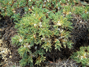
Astragalus echinus var. chinistrae (Photo: A. Kyratzis)

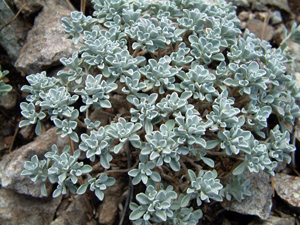
Alyssum troodi (Photo: A. Kyratzis)

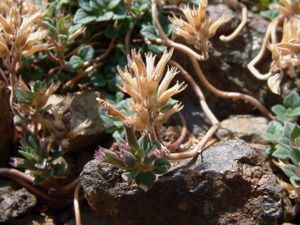
Acinos troodi (Photo: A. Kyratzis)
With an area of 9,251 km2, Cyprus is the third largest Mediterranean island. It is situated at the eastern most end of the Mediterranean Basin. The neighboring countries are Turkey about 75 km north, Syria about 105 km east and Greece about 380 km west.
The island has an irregular outline, with numerous bays and headlands, which in conjunction with the climate, the geology and the presence of man since 8,200 AD affect the distribution of vegetation. The geomorphology of Cyprus is distinguished by two main mountain ranges, 'Troodos' (1,952m a.s.l.) and 'Pentadaktylos' (1,024m a.s.l.). The Troodos massif, located in the west and south west, consists predominantly of igneous rock, while along its southern and eastern flanks stretch extensive elevated areas of chalks and limestones. The Pentadaktylos range is mainly composed of hard limestones and marbles, it has a length of approximately 80 km and extends west to east roughly parallel with and close to the north coast. The Mesaoria plain, a broad sedimentary plain, extends across the island from Morphou bay, in the west, to Ammochostos bay in the east, separating the Troodos and Pentadaktylos range. It is an arid treeless plain consisting chiefly of fertile agricultural land with the greatest part lying at about 200m. The coastline ranges from steep cliffs and rocky shorelines with sea caves to gentle slopes and sandy beaches. Most rivers originate from the Troodos range and are intermittent, with few perennial flow parts.
Cyprus has an intense Mediterranean climate with the typical seasonal rhythm strongly marked in respect of temperature, rainfall and weather generally. Hot dry summers from mid May to mid September and rainy, rather changeable, winters from November to mid March are separated by short autumn and spring seasons of rapid change in weather conditions. Local meteorological phenomena are influenced by the Troodos and Pentadaktylos ranges, and also by the proximity to the sea. The annual average precipitation is 480 mm, and ranges from 300 mm on the central plain to 1,100 mm on the peak of Troodos.
Vegetation and Habitats
It is estimated that 48% of the island is agricultural land, 44% is forest and semi natural areas, 8% is artificial surfaces, and less than 1% is covered by wetlands or open water.
High forests cover about 17% of the island, extending mainly on the Troodos and Pentadaktylos ranges. The hills are covered by shrubs alternating with built areas and cultivations. The plains of the lowlands are covered by cultivations and habitations, but there are also small areas of natural habitats locally. The natural and semi-natural vegetation types as well as the cultivations, especially traditional ones such as tree orchards, constitute important habitats for rare plants.
The Calabrian pine (Pinus brutia) forms the most extended forests, from sea level to about 1400m, and covers the Troodos and Pentadaktylos mountain ranges and part of Akamas Peninsula. Mediterranean Cypress (Cupressus sempervirens) forests occur mainly on Pentadaktylos. Forests of Pinus nigra subsp. pallasiana and Cedrus brevifolia and stands of the mountain juniperus are restricted to the higher altitudes of Troodos. The golden oak (Quercus alnifolia) occurs under the conifers or in pure stands, at altitude of 700 m and above all across Troodos range.
Various types of shrub are dominant in the thermo-Mediterranean bio-climate and semi arid zones. Olea europea and Ceratonia siliqua as well as Quercus coccifera subsp. calliprinos tall shrubs are rather rare, while the low and spiny phrygana are the most common vegetation type. Juniperus phoenicea matorral is typical of the coastal zone. Dry grasslands develop in pastures and in shrub and forest openings.
The sandy coastal zone is generally narrow, with Ammophilus communities and low embryonic and shifting dunes. Extended dune systems, including stabilized dunes with shrubs and dune slacks, develop at few places, notably in connection with halophytic wetlands.
A discontinuous and mostly narrow line of riparian shrub and forest develops along the numerous streams that dissect the island, often in the midst of cultivated land. Standing fresh water bodies are only artificial storage basins and dams, yet hydrophilous vegetation has established at most of them.
The rocky habitats include chasmophytic communities developing on limestone ultramaffic rock and wet rocks, and also endemic serpentinophilous chamaephytic communities.
Forty nine of the Habitats listed to the Annex I of the Directive 92/43/EEC exist in Cyprus out of which fourteen are considered as priority Habitats. The Habitats 9390, 93A0, 9590, 6460 and 62B0 occur only in Cyprus.
Flora
The publication of the Flora of Cyprus (Meikle 1977, 1985) was a milestone in the study of the flora of Cyprus, which began in 1787 and has been continuous up to now with the discovery of new indigenous and alien taxa and new endemic taxa. In total the indigenous flora of Cyprus includes 1,610 species or 1,738 taxa at variety level, while the alien flora includes 238 taxa. The endemic flora includes 108 species or 143 taxa at variety level (6.7% and 8.2% of the indigenous flora respectively). The National Forest Park of Troodos is a center for endemics, hosting 13 local endemics and 74 Cyprian endemics, while the whole Troodos range hosts 94 endemic taxa. Other important areas for endemics are the Pentadaktylos range and Akamas Peninsula with 56 and 44 cyprian endemic taxa, respectively.
Eighteen taxa are listed to the Annex II of the Habitat Directive (92/42/EEC) and twenty seven taxa are listed to the Annex I of the Bern Convention. All species of the genus Cyclamen and all species of the family Orchidacea are listed to the Annex II of the Convention of International Trade in Endangered Species (CITES).
Threats to the Cypriot flora
According to The Red Data Book of the Flora of Cyprus (2007), 23 plants are classified as regionally extinct (RE), 46 plants as endangered (EN), 128 as vulnerable (VU), 45 plants as data deficient (DD), 15 plants as near threatened (NT) and 7 plants as least concern (LC). Forty five endemic plants (31.5% of the endemic flora) are included to the list. The areas with the largest concentration of plants are the National Forest Park of Troodos, Pafos Forest, Madari-Papoutsa area, Akamas Peninsula, Akrotiri Peninsula, Kavo Greko and the Pentadaktylos range. The most threatened plants occur in maquis and phrygana whereas the habitats with the highest concentration of threatened plants are wetlands, coastal habitats and inland rocks.
The Habitat loss or degradation due to human activities is recorded to The Red Data Book of the Flora of Cyprus (2007) as the main threat for the flora of Cyprus. Degradation is most frequently caused by building and tourism development and road construction followed by agricultural activities. Human disturbance, mainly recreational use directly affecting plants, is also an important threat. The typical Mediterranean climate threats of fire and drought which will probably be aggravated by global climate change were recorded with significant frequency. The importance of the threat of land development is indicated by the fact that the plants showing population reduction or habitat degradation are located on coastal sand dunes, in phrygana and agricultural areas, which are habitats most affected by building and tourism activities.
References
CORINE Land Cover 2000 (CLC2000) Cyprus. Final Report. Ministry of Agriculture, Natural Resources and Environment. Lefkosia, 2005.
Meteorological Service webpage
[http://www.moa.gov.cy/moa/ms/ms.nsf/DMLindex_en/DMLindex_en?opendocument]
The Red Data Book of the Flora of Cyprus (2007). Ed T. Tsintides, C.S. Christodoulou, P. Delipetrou, K. Georgiou. Cyprus Forest Association, Nicosia 2007.
Έκθεση για την Κατάσταση του Περιβάλλοντος 2007. Υπηρεσία Περιβάλλοντος. Υπουργείο Γεωργίας, Φυσικών Πόρων και Περιβάλλοντος.


