


Sardinia - Island characteristics overview
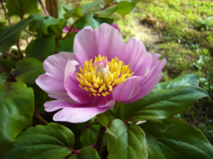
Paeonia corsica (Photo: A. Santo)
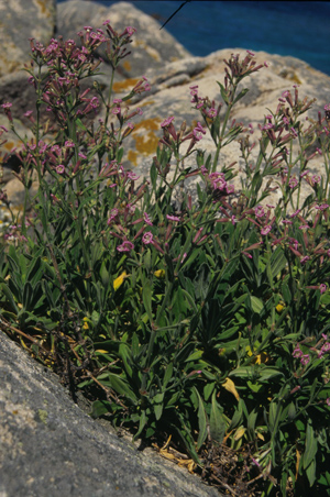
Silene velutina (Photo: G. Bacchetta)
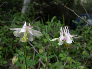
Aquilegia barbaricina (Photo: G. Bacchetta)
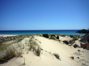
Coastal sandy dunes of Su Giudeu (Photo: A. Santo)
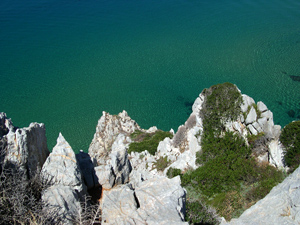
Coastal cliffs of Buggerru (Photo: G. Bacchetta)
Sardinia is situated in the Western Mediterranean basin, administratively belonging to Italy, spanning from 38°51’52’’ N latitude (Teulada Cape) to 41°15’42’’ N latitude (Falcone Cape) and from 8°8’10’’ E longitude (Argentiera Cape) to 9°50’8’’ E longitude (Comino Cape). Sardinia is about 178 km from Cap Serrat (Tunisia) and 188 km from the Argentario Promontory (Tuscany, Italy) and it is separated from the Balearic Islands and the Iberian Peninsula by the Sardinia Sea (about 342 km from Minorca and 430 Km from the Catalan coast) while the Provençal coast is a little nearer (about 275 km from Stintino).
Sardinia features a surface of 23,821 km² (24,089 km² together with the minor islands administratively belonging to the Sardinian region) and it is the second largest island in the Mediterranean after Sicily. Unlike the Italian peninsula and Corse, Sardinia, has been marginally affected by the Alpine orogeny, thus not featuring very high mountains, having as the major mountain the Gennargentu massif (Punta la Marmora 1,834m a.s.l.), Supramonte (Mount Corrasi 1,463m a.s.l.), Mount Limbara (Punta Balistreri 1,362m a.s.l.) and Mount Linas (Punta Perda de Sa Mesa 1,234m a.s.l.). The mountainous areas (= those above 600m a.s.l.), represent 13.6% of the whole territory and they consist mainly of basalt or limestone hills and rocky plateaus.
From a morphological point of view, the island is distinguished from the nearby Corse and the other Mediterranean islands by the antiquity of its relief that has been shaped into low hills and plateaux by the weathering. In the eastern part silicate lithologies and, subsequently the Mesozoic limestones, are forming a series of relatively high reliefs as far as the coast. The western portion is characterized, in the center-northern area, by volcanic rocks and those sedimentary from the Tertiary (mainly Oligocene and Miocene). Differently, in the Nurra area (NW Sardinia) and in the Sulcis-Iglesiente (SW Sardinia) paleozoic lithologies are predominant.
The average annual temperature in Sardinia varies from 11.6°C in Genna Silana to 17.6°C in Cagliari. According to Rivas-Martínez (2008), the Sardinian climate can be described as oceanic on the basis of the continentality index and principally set in the semihyperoceanic, the euoceanic and in the semicontinental subtype, while concerning bio-climate the most representative is the Mediterranean pluviseasonal oceanic (MPO). Three thermotypecharacterize the MPO, the upper Thermomediterranean, the lower and upper Mesomediterranean and the lower Supramediterranean. At the end, concerning the ombrotype, in Sardinia there are at least the upper and lower dry, the lower and upper subhumid and the lower humid ones (Bacchetta et al. 2009).
The Checklist of the Italian Vascular Flora (Conti et al., 2005; 2007) ascribes to the Sardinian flora 2,494 taxa while, after the latest floristic researches, the number of taxa has raised approximately up to 3,000 (Bacchetta et al., unpublished data). 291 taxa of the Sardinian flora are included in the regional Red List of Italy (Conti et al., 1997) and are distributed in the following IUCN categories: 5 EW, 39 CR, 41 EN, 69 VU, 119 LR, 17 DD and 1 NE.
From a chorological point of view, the Circumediterranean chorotype is predominant (29%), followed by Asian-European chorotype (17%) and by the Euromediterranean element (16%) (Pignatti 1994).
Bacchetta et al. (2005) have listed 347 endemic taxa (e.g. narrow endemics, Sardinian endemics, Corso-Sardinian endemics, Corso-Sardinian-Balearic endemics), with 45.8% being exclusive Sardinian endemics. Its isolation and high geological diversity have created a wide range of habitats, with high levels of endemism, especially on its mountain massifs, where there are conditions of ecological insularity (Médai l & Quézel, 1997). The acknowledgement of a autonomous biogeographical Sardinian-Corsican province is based on a large contingent of endemic entities that are exclusive of the two islands, including the two monotypical genera Morisia and Nananthea. Another important feature of the Sardinian flora is the presence of a certain number of taxa that differentiated in ancient times, such as Centaurea horrida, Bellium crassifolium and Helichrysum montelinasanum.
Many natural habitats that characterize the Sardinian territory and its important plant areas (IPAs) are still not under protection. Among them, the sandy coastal dunes, the halophilous marshes, the coastal cliffs, the orofitic habitats, the grasslands of the Thero-Brachypodietea class, the Mediterranean temporary ponds, the mining environments and the riparian woods are those which better characterize the richness of the Sardinian flora.
Up to now 34 (IPAs) have been pinpointed in the Sardinian territory, covering approximately 18% of the regional area and 10% of the total Italian surface that has been considered remarkable for plant conservation (Blasi et al. 2010). Notwithstanding, many of these IPAs currently are not under any kind of protection or, at least, not for the entirety of their area but they are under severe threat due to the overexploitation of natural resources, grazing and tourism.
References:
Bacchetta G.,Iiriti G., Pontecorvo C. (2005). Contributo alla conoscenza della flora vascolare endemica della Sardegna. Informatore Botanico Italiano, 37(1, Parte A):306-307.
Bacchetta G., Bagella S., Biondi E., Farris E., Filigheddu R., MossaL. (2009). Vegetazione forestale e serie di vegetazione della Sardegna (con rappresentazione cartografica alla scala 1:350.000). Fitosociologia, 46 (1) suppl. 1: 3-82
Blasi C., Marignani M., Copiz R., Fipaldini M., Del Vico E. (Eds.), (2010). Le Aree Importanti per le Piante nelle Regioni d’Italia: il presente e il futuro della conservazione del nostro patrimonio botanico.- Sapienza Università di Roma, Progetto Artiser, Roma. 224 pp.
Conti F., Abbate G., Alessandrini A., Blasi C. (2005). An annotated checklist of the italian vascular flora. Palombi Editore, Roma
Conti F., Alessandrini A., Bacchetta G., Banfi E., Barberis G., Bartolucci F., Bernardo L., Bonacquisti S., Bouvet D., Bovio M., Brusa G., Del Guacchio E., Foggi B., Frattini S., Galasso G., Gallo L., Gangale C., Gottschlich G., Grünanger P., Gubellini L., Iiriti G., Lucarini D., Marchetti D., Moraldo B., Peruzzi L., Poldini L., Prosser F., Raffaelli M., Santangelo A., Scassellati E., Scortegagna S., Selvi F., Soldano A., Tinti D., Ubaldi D., Uzunov D. &Vidali M.(2007) Integrazioni alla Checklist della flora vascolare italiana. Natura Vicentina 10: 5-74.
Médail F.,Quézel P. (1997). Hot-spots analysis for conservation of plant biodiversity in the Mediterranean Basin. Annals of the Missouri Botanical Garden 84: 112-127.
Pignatti S. (1994). Ecologia del paesaggio. UTET, Torino.
Rivas-Martínez S. (2008). Globalbioclimatics. Internet: http://www.globalbioclimatics.org.